Surfridge, Tehachapi & Thomas Guide: How Southern California Moves
Season 9 Episode 1 | 28m 8sVideo has Closed Captions
Nathan visits Surfridge, the Tehachapi Loop and the largest collection of Thomas Guides.
Planes, trains and autos shape the way people move through the city as population grows. Walk through Surfridge, lookout over the Tehachapi Loop and visit the Thomas Guide. Trace how transportation reshaped the region and where it is always documented.
Problems playing video? | Closed Captioning Feedback
Problems playing video? | Closed Captioning Feedback
Lost LA is a local public television program presented by PBS SoCal
Surfridge, Tehachapi & Thomas Guide: How Southern California Moves
Season 9 Episode 1 | 28m 8sVideo has Closed Captions
Planes, trains and autos shape the way people move through the city as population grows. Walk through Surfridge, lookout over the Tehachapi Loop and visit the Thomas Guide. Trace how transportation reshaped the region and where it is always documented.
Problems playing video? | Closed Captioning Feedback
Where to Watch Lost LA
Lost LA is available to stream on pbs.org and the PBS app.
Providing Support for PBS.org
Learn Moreabout PBS online sponsorshipNathan: So four or five decades after the houses came down here, nature really is taking over it.
I mean, we are walking atop sand dunes, right?
Meredith: Yes.
Doug: Okay.
Maybe right now, just to the left of that tree in the middle, you see a light.
Nathan: Oh, I see it.
Yeah.
Doug: Bingo.
Nathan: It's coming up.
These are some well-loved atlases.
Peter: When you consult your own Thomas Guide, you can really have a much better sense of your own community.
[Train horn blaring] Nathan: This is a big bell.
Doug: Yeah.
It's not working.
[Bell tolls] Doug: Yeah, it works.
[Laughter] Doug: It works.
Announcer: This program was made possible in part by a grant from Anne Ray Foundation, a Margaret A. Cargill Philanthropy, and the Roy and Patricia Disney Family Foundation.
Nathan: In little more than a century, a sparsely populated landscape of cattle ranches, bean fields, and orange groves became one of the largest metropolitan regions on Earth.
You might say that Southern California didn't just grow, it erupted.
The story of how that happened and what it costs is written into the landscape itself and in the maps we once used to navigate it.
So Doug, Tehachapi is a town about 70 to 80 miles as the crow flies north of Los Angeles.
Doug: Uh-hmm.
Nathan: A lot of Southern Californians maybe have never even been here.
Doug: No, they can't spell it, that's for sure.
Nathan: [Laughs] Right.
And yet, this is one of the most important places in the history of Southern California.
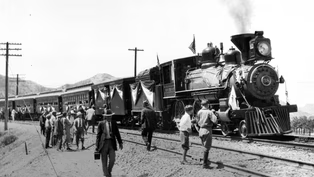
[Train horn blows] Nathan: The modern metropolis of Los Angeles might never have come into existence without a single feat of engineering.
In 1876, the transcontinental railroad finally crossed the mountain ranges that divided Southern California from the rest of the country.
And it changed everything.
I'm headed to the Tehachapi Depot Museum up in Kern County to meet with local historian Doug Pickard.
Doug: Well, come on up here and I'll show you some more of the--what we have here.
Nathan: Wow.
Doug: This is a railroad map of the state of California.
And, you know, most Californians know there's the big Central Valley surrounded by mountains.
The first intercontinental railroad or transcontinental went over Donner Pass, Truckee, and went to Omaha.
Nathan: This was 1869.
The transcontinental railroad?
Doug: Correct.
And as soon as they finished that, they started--they knew they wanted to build down towards Los Angeles and Southern California.
They started building our railroad here.
And, uh, there were several different choices of how to get over the mountains.
But Tehachapi was deemed the best choice.
Nathan: Because the Sierra Nevada is just such an imposing mountain range.
Doug: Right.
When this railroad going south was originally chartered with the government, it was to go through Tehachapi and then go over to the Colorado River.
In 1872, the citizens of Los Angeles, they voted $600,000 plus an already existing LA and San Pedro Railroad, that they were gonna give them to change the route and build into LA.
So I shouldn't use the word "bribe"-- Nathan: Yeah, an incentive.
Doug: Yeah.
Okay.
[Chuckles] Nathan: But they, uh, did effectively bribe the railroad company into making Los Angeles a terminus, which was a huge decision, uh, in the history of LA.
[Upbeat music playing] Nathan: This is a big bell.
Doug: Yeah.
It, uh, weighs over 300 pounds.
Nathan: Oh, wow.
Doug: And we have the documentation that it was, uh, put on an engine that was built in 1913 for the Union Pacific Railroad.
It's not working.
[Bell tolls] Doug: Yeah, it works.
[Laughter] Doug: It works.
Nathan: Yeah.
Woo.
That's more of an outdoor bell.
[Laughter] [Upbeat music playing] Doug: And, Nathan, I'd like to introduce Mark McGowan.
Nathan: Mark, pleased to meet you.
Mark: Pleased to meet you.
Doug: Mark went to high school in Tehachapi and went to work for the railroad, and he was a signal maintainer, I think, if I got that right.
Mark: Signalman, yeah.
Doug: So, uh, you explain these to what they do and stuff, and I'll go in and see if I can make them work.
Nathan: Mark, I've been to a lot of gardens but I think this might be my first signal garden.
[Laughter] Mark: All of these signals belonged to my first boss, his name was Bill Stokoe.
And these were all, at one time, in his backyard... Nathan: Okay.
Mark: and they donated them to the museum, and they have been put back.
These all worked in Bill's backyard and they all work here.
[Upbeat music playing] Nathan: The signals Mark showed me were once part of the vast network of track connecting Southern California to the rest of the nation.
There's just one problem with train history, you never quite know when history is gonna come rumbling through.
[Train horn blaring] [Train tracks rumbling] Doug: I didn't see the engine to know what--which train it is.
Nathan: You can really feel-- you can feel the train moving here.
I mean, it's... Doug: Yeah, yeah.
Nathan: If you had a seismometer, that would register.
The spot where two sets of tracks met in 1876 on a homestead in the Santa Clarita Valley known as Lang Station is celebrated as California's golden spike moment.
But none of it would've been possible without a feat of engineering some 50 miles to the north where the railroad had to climb nearly 4,000 feet through the Tehachapi Pass.
Tehachapi is actually the most important piece of track built for Southern California's history because it was the most challenging.
Doug: Yes.
Uh, an engineer by the name of William Hood who had got his experience building the first cross-country railroad up by Donner Pass, they put him in charge of building the railroad down through here, and he had a certain limiting grade.
So he just added a whole bunch of climbing track around in a circle, which has become known as the Tehachapi Loop.
Nathan: Kind of like switchbacks if you're on a hiking trail or a mountain road.
Doug: Yeah.
Nathan: Trains are just so much more sensitive to grades than automobiles, right?
Like the iron-- the steel would just slip.
Doug: Amazingly, do you know that all these engines carry sand and if the wheels start to slip, he can push a button and it'll put sand in front of the wheel?
Nathan: Okay.
So if that's not the problem, then what is?
It's--just too much... Doug: The amount-- the amount of power.
Yeah.
So he had learned from experience that there was a certain angle, he shouldn't make it any steeper, 2.2%.
Going downhill, it's just as bad.
You don't have brakes.
Enough brakes.
Nathan: Maybe even worse really.
Yeah.
Doug: So back in the old days, they would have a man riding on top of each car, and if the engineer needed brakes, he'd blow the whistle and the guys would all go trying to put the brakes on by hand on each car.
Nathan: They're called brakemen, right?
Doug: That's right.
Yeah.
So people come from all over the world that are train nuts... Nathan: Uh-hmm.
Doug: to see the Loop.
Nathan: Well, let's go take a look at the real thing.
Doug: Okay.
Works for me.
Nathan: Doug took me to a spot on the old highway between Tehachapi and Keene, a vantage point that hasn't changed much in 150 years, to see the Loop for ourselves.
When you look at it here in person, I mean, you can really see that this was a huge undertaking.
I mean, as was most of the construction of the transcontinental railroad and then to link it between Northern and Southern California.
Doug: Manual labor.
Nathan: Manual labor.
And the people who played a big role in that were people who weren't even citizens of this country, in many cases, weren't even permanent residents.
They had come over here to Gold Mountain... Doug: Yeah.
Nathan: uh, to raise money for their families and send it back home, and they worked here in really harsh conditions and did the most dangerous work on this railroad.
We're talking about the Chinese laborers.
Doug: Go back to not our railroad but the first transcontinental.
There were two different companies, one company was in Omaha building to the west, the Union Pacific.
Central Pacific was growing to the east.
Nathan: Right.
Doug: Well, the Union Pacific, they had available to them all the railroad construction workers that had built already to Omaha.
So they had a huge pool of labor.
The people here on the West Coast, we didn't have any pool of labor at all.
There were Chinese people that would-- were willing to work.
Nathan: So if we go back to those original days when they were building this track for the first time, all of the food, all of the construction supplies had to be trucked up here on wagon probably.
Doug: Wagon, yes.
Nathan: Yeah, by wheel, I mean.
Doug: No, I-- when we first got down here a half hour ago, I said if you take and Photoshop the freeway out of this picture, you've got what it looked like 150 years ago.
Nathan: Yeah.
Doug: Okay.
Maybe right now, just to the left of that tree in the middle, you see a light.
Nathan: Oh, I see it.
Yeah.
Doug: Bingo.
Nathan: It's coming up.
[Train horn blaring] Nathan: Some people might say that the railroad age ended long ago, but America still runs on trains.
Doug: Oh, it's gonna be a long time before railroads go away.
Nathan: Yeah.
Doug: Everything gets moved.
[Train horn blaring] Nathan: The Tehachapi Loop didn't just connect Southern California to the rest of the nation, it set off an explosion of growth that would remake the landscape for generations.
And somebody had to keep track of it all.
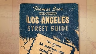
If you grew up in Southern California before Google Maps or Waze, you know the Thomas Guide.
The spiral-bound street atlas was practically a requirement for navigating a city too sprawling for any single map.
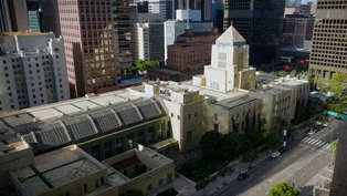
I brought my own well-worn copy, a 1974 edition, to the Los Angeles Central Library where map librarian Peter Hauge oversees the only known complete collection of the Thomas Guide's LA/Orange County Edition.
So if you're from Southern California, you know the Thomas Guide.
It was something idiosyncratic to the city.
And in one ways, it was a shibboleth of the city, right?
Peter: Absolutely.
It was definitely the--you know, almost a code word, uh, you knew who was, uh-- who was on the in and who was on the outside, you know, based on their reaction to the Thomas Guide and how well they can use one for sure.
That looks like a well-loved Thomas Guide.
Nathan: It is well-loved.
And it's funny, like, uh, you know, there are certain pages missing and they are connected to what my father was doing.
So, you know, he went to Cal Poly Pomona, so the page for that is missing, right?
'Cause it was just used so much.
The page where my grandmother lived in Anaheim, also missing.
I mean, you can--look at-- look at this, right?
Peter: Yeah.
Nathan: Most of the atlases in your collection are in better shape, I would assume.
Peter: I definitely try to keep them in better shape.
Uh, we have had a few, uh, um, uh, Thomas Guides come to our collection that have been donations.
So there's--the condition of some them, you know, can be a little bit, uh, questionable at times.
So we have a few that, uh, that do look like that.
Nathan: You could track the region's development through here.
You can look at the 1974 edition and there would be, you know, open space here, right?
The next year, 1975, there'd be a freeway going through there.
I mean, you can probably trace a lot of the urban and regional development just through these Thomas Guides alone.
Peter: Absolutely.
They're one of the most valuable tools that we have in the library for just that.
Uh, we'll have folks coming in all the time and they'll want a very detailed, very accurate year by year, maybe every five years, looking at a certain neighborhood or a certain area of the city, and they wanna see how it's changed, stack 'em one on top of the other.
And yeah, you can absolutely see those changes take place.
It's pretty incredible.
Nathan: I wonder if we could do a little bit of that right now.
Can we look at some editions and see, like, let's say, like, one of--one of the biggest regional landmarks, Disneyland.
Can we see before and after?
Peter: Absolutely.
Yeah.
Okay.
So that would be... Nathan: It opened in '55.
So let's say the '54 edition and then just, like, one a couple years later.
Peter: Sounds good.
Let's grab it.
And it should be right here.
So you said... Nathan: '54 and '56 Orange County.
Peter: '54 and... Nathan: These are some well-loved atlases.
These were not designed to be opened in the year 2026, right?
Peter: This is true.
This is very, very true.
So, uh, turn to map 16... Nathan: Yes.
16.
Peter: of, uh, of Anaheim.
Nathan: Orange County.
Yeah.
Peter: And-- Nathan: This is two years apart.
I mean, this is actually astounding, just to look at the density of the suburban residential streets right here.
Totally missing two years earlier.
But of course, the big one, the landmark, Disneyland, right here, and the--there's nothing to say that this will be the, uh, the focal point of the amusement park industry in a--in a--in a year or so.
[Upbeat music playing] Nathan: One of the things that really fired my, uh, imagination as a kid was to look at just how freeways and actually entire municipalities would just appear, uh, on the Thomas Guide.
I think a great example-- so, like, look at Irvine.
So I think map 32 in Orange County, this is 1954.
[Peter laughs] This is our-- so this is the 1976.
Nathan: So this is a 22-year difference.
Here you have almost nothing, right?
You have McArthur Boulevard still there in '54, but the campus of UC Irvine... Peter: Uh-hmm.
Nathan: all of this, Newport Beach, Fashion Island.
Yeah.
That's all missing here.
There was--this was essentially Irvine Ranch, cow-grazing land.
[Soft music playing] Nathan: This is thousands of hours of labor that went into this.
How did they put together these maps?
You couldn't--you couldn't drive every little street.
Peter: Uh, well, they oftentimes did.
I mean, some folks would, uh, would go-- uh, would go street by street.
There, uh, there was definitely, uh, aerial photography that, uh, that was used.
But I believe a lot of these were done by hand.
But when we get into '92, we now have the intelligent map digitally published.
Nathan: I grew up on page 12.
[Laughter] Nathan: And here we have the 91 Freeway, the 55 Freeway, the 57, and, of course, no freeways here.
And I mean, this is the story that a lot of people experienced as they grew up.
They saw the region grow up around them, you know, with them.
And, uh, you can-- you can see it right here.
And you go all the way back to-- what year is this?
Peter: This is an interesting one.
This is a 1945 edition that, uh, that we have in amazing shape.
And I believe this one may have, uh, appeared after, uh, excavating a really interesting story of map history in Los Angeles.
In 2012, there was a house that was being sold.
The occupant had passed away.
And the realtor contacted my predecessor and told him that there-- Nathan: The great Glen Creason.
Peter: The great Glen Creason.
Absolutely.
And told him that there was a house filled to the brim with maps.
And I was-- Nathan: They weren't joking, were they?
Peter: They were not joking.
And at the time, I was just a plucky young volunteer, uh, you know, lurking around, really interested in maps.
Uh, Glen had my number and he reached out to me.
And I was so excited and said, "I need your help."
So we went down to the house together and we unloaded a house filled with maps.
They were under the bed, they were under the mattresses.
Uh, I pulled out a stereo from the closet.
It was really interesting.
It looked really nice.
And as I pulled it out, the weight didn't feel too right.
And as I turned it around, the guts of the stereo had been pulled out and instead, it was just filled with maps.
They were everywhere.
Nathan: And we--because of that, for that, we have this.
This is, uh--this is, I guess, before they started making the glove-compartment-sized ones.
This would be like to fit in a jacket pocket almost, right?
Peter: Yeah.
Which was-- which was a very common, uh, format, uh, at the time.
When folks were still, you know, messing around with these street guides and, you know, some of the best formats for 'em, you'll see folks, um, carrying around things like, uh, the Renie Guides, uh, or even before that Gillespie Guides, have that very nice, uh, nice pocket size format.
Nathan: That was the standard.
Peter: Yeah.
Nathan: But then the Thomas Guide came along.
They figured, "Hey, this is something for the automobile."
Peter: Uh-hmm.
Yes.
Nathan: We can make the pages a little bit bigger.
Peter: Make 'em bigger, make it a little easier to have out on your lap.
Nathan: So we call these Thomas Guides, but the company was the Thomas Brothers, Thomas Brothers Maps.
Now who were the Thomas Brothers?
Peter: So the Thomas Brothers, it was, uh, George Copleland Thomas.
Uh, he was the-- uh, he was the one you hear about all the time.
Uh, he was the, uh, the one who started the company with his two brothers.
And they were making maps, uh, up in San Francisco, and they started in 1915.
Uh, they were in the, uh, the Oakland area.
They moved down to Los Angeles in, uh--around the 1940s.
Before that, they were, uh, making wall maps.
Uh, they were making tourist maps that, uh, that you might find, uh, your standard fold-out maps.
Nathan: Their motto, if it's a map, we have it.
Peter: Yeah, right.
The company was eventually purchased by Rand McNally, the big, big map makers... Nathan: Yes.
Peter: uh, in 1999.
Uh, and they're the ones who are still producing the, uh, the maps today.
And we still have Thomas Guides as a requirement in emergency vehicles in California to this day.
Some folks are critical of later editions.
They think they were better back in the olden days.
Uh, but I like the newer ones for just that very reason.
I think they've managed to give you a lot more information in a very unobtrusive way.
And having a lot of these neighborhoods, um, highlighted, you know, is important.
Nathan: Yeah.
Look at-- just look at page 633.
You have, what, five different neighborhood names here?
And here there's, what, a dozen?
Peter: Uh, yeah.
Uh, we have, uh, Koreatown, Harvard Heights, Arlington Heights, Lafayette Square, Little Ethiopia, uh, Jefferson Park, Sentous.
Nathan: I haven't even heard of some of these.
[Laughter] Nathan: So what are your thoughts on just the mass migration over to digital maps, the GPS devices?
Peter: I mean, it's easier.
I use a--I use a GPS mapping all the time.
It's nice to have it tell you where you're going and all that.
But I still carry a Thomas Guide in my car.
Nathan: You do?
Peter: I absolutely have the latest edition of the Thomas Guide in my car.
I wish more people would.
I wish more people would explore the physical map because it's one thing to pull your phone and, uh, look at-- look at where you are.
But when you consult your own--your own sheet of a--of a Thomas Guide, you can really have a much better sense of your own community and really see like, "Oh, my gosh.
Hey, I didn't even realize I am right around the corner from a school or, you know, police station" or what have you.
Nathan: Yeah, you're part of a community that might be part of a page, but then you're also part of a--of a--of a region that's part of this atlas.
Peter: Yeah, absolutely.
I have definitely had folks still coming in today and they'll just say, "Do you just have a Thomas Guide?
Do you just have a map?"
They just--they just want, uh, something very simple that they understand and that are familiar with.
And they're very happy to see that we still have-- uh, we still have those Thomas Guides.
Nathan: The Thomas Guide gave Southern Californians a way to see their region from above, to watch it grow page by page, edition by edition.
But the consequences of that growth?
That can only be understood at ground level.
So that's Dockweiler Beach down there.
I've been running down there, and it's really fun with the airplanes coming overhead.
Meredith: It's amazing.
Nathan: But I can imagine that if you lived here, you wouldn't be, uh, praising the airplanes.
Meredith: Yeah.
I mean, having to, like, think about stopping every couple of minutes while the dishes rattle and, you know, the conversation stops, yeah.
[Airplane engine roaring] Nathan: So this was part of a larger development called Palisades del Rey that extends all the way up to present day Playa del Rey.
And this was where in what was called Surfridge Estates.
But back when this was developed in the 1920s, Mines Field, which is what is today LAX, was at least a mile out there.
And it was a small airport, propeller-driven craft.
And that was way out in the countryside on bean and barley fields.
Didn't look like it was gonna ever encroach on any suburban development.
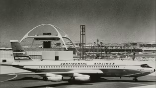
Meredith: Moving from those propeller planes to the jet age, by the time the '50s, and the '60s, and the '70s hit, I mean, transportation, mechanisms had changed and LAX got bigger and bigger and bigger, the runways needed to get bigger and bigger and bigger and they got closer and closer and closer.
Nathan: This is an interesting case study in eminent domain because we usually talk about eminent domain being used against communities that you would call, maybe, marginalized or disenfranchised.
Whereas right here, this was a middle class/, you know, relatively wealthy neighborhood right on the beach.
Meredith: Right on the beach.
It's very hard to put it into that, kind of, classic story about eminent domain.
Nathan: Transportation is obviously-- it's something that makes the modern metropolis possible.
It helps you get around the city, connects LA with other cities, but it has costs.
Meredith: You know, I think when the neighborhood was first established, I don't think they had any idea at the scale of what was going to become, you know, this international global connection and hub.
But I think it's important to put this in the context of a larger LA story, thinking about the ways that transportation has been used both to move the city forward as a, kind of, a bigger, um, metropolis, but also the consequences and the displacement of the people who actually lived in the neighborhoods that get chosen as the sites for these hubs.
So we can obviously start with Union Station and the displacement of the Chinese community.
We can think about freeway expansions and, sort of, cutting through neighborhoods.
And then LAX, um, I think, offers a, sort of, a long line in the continuum of thinking about how does LA connect both locally and globally.
And, sort of, what I've been thinking more about lately is Vandenberg Air Force Base and the rockets that are now launching.
There are new neighborhoods that are in the path of this big transportation.
So it's intergalactic, it's local, it's domestic, it's international, it's all, kind of, part of that story.
Nathan: Courtesy of the Center for Land Use Interpretation, we do have these amazing real estate listings from the '60s.
I think we could probably find some of these houses.
Meredith: I'd love to.
Nathan: You wanna go check it out?
Let's go take a look.
[Dramatic music playing] Nathan: But one of the ironies of this place is that when it was being developed, the developers, they used a few things as a starting point.
They donated land from Loyola University, they built a beach club, and then they also pointed out the proximity to the brand new Mines Field LA Airport.
Meredith: Yeah, I mean, that's totally not surprising, right?
I mean, proximity to freeways, proximity to airports, I think that was part of this.
You could go anywhere.
Nathan: So here we are.
Here, let's take a look at this.
Meredith: Oh, yeah.
Nathan: Yeah, we are at 9126 Trask Avenue.
And this is the house right here.
Meredith: Oh, and it's so beautiful.
And I think what we're looking at right now is a driveway.
And so you can imagine... Nathan: Yeah.
Here's the curb cut right here.
Meredith: pulling the-- this sort of, huge car in.
Nathan: [Laughs] Right.
Meredith: I think one of things that, like, it's really exciting as a historian is to have these records that, sort of, can live on even though the physical has, sort of, been demolished.
But it just-- it, um, enables us to do exactly this, to stand in a place where something once existed.
And so these, like, archives are amazing.
Nathan: I mean, this is a real estate listing, just like what you'd find on Zillow today.
But it tells a story.
Meredith: Yeah.
So onto the next one?
Nathan: It's down this way, right?
Okay.
Surfridge is unlike any ghost town I've ever visited.
Walking its once suburban streets today, you find yourself longing for the most mundane sounds of Southern California life, a lawn mower, a sprinkler, even a gas-powered leaf blower.
But all you get is the roar of jet engines and the hiss of blowing sand.
So four or five decades after the houses came down here, nature really is taking over.
And it's not just the plants.
I mean, we're walking atop sand dunes, right?
And that's actually what you really see is the sand is reclaiming this neighborhood.
Meredith: If you're looking at, like, what's here and it's really, like, beach.
Nathan: You know, when they started building this back in the '20s, there was a scarcity of coastal land that wasn't already occupied by amusement concerns.
So one of the rules here is that nobody could build a pier or an amusement park or anything else 'cause, you know, Venice, Santa Monica, the coastline was all taken up.
So this was some rare residential coastal property.
So this is where we are right here.
We're at 255 Jacquelin Street, three bed, one bath.
It's going for $34,950.
Meredith: Sounds like a good price.
Nathan: Yes.
I know.
Meredith: And for how long was it standing from that point on?
Nathan: Uh, yeah.
I mean, the eviction process, or at least the expansion that set the eviction process in place, that happened in-- started in '68.
But this house might have been here for 20 more years, right?
Meredith: I mean, that is one of the interesting things I think about.
This is-- it was such a long, drawn out, slow decay of a particular neighborhood as, kind of, one family left after the other.
Nathan: So the best line here is the property will go up in price as this section of Playa del Rey is excellent.
And they wrote that after the introduction of jets here.
This was a few years before this area was condemned.
Meredith: I think we're looking at real estate language, historic real estate language.
You know, some things never change, right?
Nathan: Right.
Meredith: This is due to go up in value.
Um... Nathan: So one other interesting wrinkle is that at the same time the airport was eyeing this land for whatever use... Meredith: Yeah.
Nathan: there were residents on the other side in Inglewood who were encouraging the airport to extend the runways all the way to the ocean so they would have a higher approach.
So there were, like, homeowners in one area who were in conflict with homeowners on the other side of the airport.
Meredith: Yeah, I mean, that, in and of itself, is, uh, the true definition of the challenges of regional planning is that, you know, we have set up a system where so many small municipalities, you know, especially LA with, like, multiple jurisdictions, it pits people against each other.
And it's a--it's a big regional network with lots of different implications.
Nathan: Now we can hear the waves crashing.
Meredith: And that sea breeze really is strong here.
Nathan: So you're somebody who has a background in both history but also urban planning.
Meredith: Yeah.
Nathan: You know, what lessons can you take away from the story of Surfridge as LA continues to evolve into the future?
Meredith: Thinking as an urban planner first.
We have an obligation to plan regionally.
We really do have to think about LA as part of a larger ecosystem, you know, of transportation, of wildlife, of communities.
And we have an obligation to the people who live here to plan effectively so that people can make decisions.
I also think history really does matter because it gives us the opportunity to think about how we didn't do it quite right and how we could do it better in the future.
Nathan: Now LAX, maybe not everybody's favorite airport, but we really couldn't do without it either.
Uh, every time somebody gets on a plane and flies out of LAX, they can look down and see this neighborhood.
I mean, what should--what should people think as they fly over Surfridge?
Meredith: I know that I won't see this neighborhood in quite the same way.
There was a community here.
Children grew up here.
Skateboards and surfboards and hula hoops, and all of those things that make Southern California what it is, were-- what--they were here.
It's a good reminder of the choices that we make in order to serve the larger region.
Nathan: Yeah, those are the human lives that give a place meaning.
You can't see that 35,000 feet up.
You have to walk through the neighborhood.
Meredith: That's why I'm a planning historian.
I believe in urban planning, I believe in, sort of, planning for the future, but I also believe in understanding decisions that were made in the past because I think that actually gives us the capacity to make better decisions.
And this is an example that we should learn from.
[Airplane engine roaring]
How the Thomas Guide Reveals a Changing Los Angeles
Video has Closed Captions
Clip: S9 Ep1 | 8m 50s | The street atlas that defined how Southern Californian's navigated their city. (8m 50s)
Surfridge, Tehachapi & Thomas Guide: How Southern California Moves (Preview)
Video has Closed Captions
Preview: S9 Ep1 | 30s | Nathan visits Surfridge, the Tehachapi Loop and the largest collection of Thomas Guides. (30s)
Surfridge: The Beachside Neighborhood Erased by LAX
Video has Closed Captions
Clip: S9 Ep1 | 9m 8s | A lost coastal neighborhood erased by the expansion of Los Angeles airport. (9m 8s)
The Tehachapi Railroad Loop Still Powers California Trade
Video has Closed Captions
Clip: S9 Ep1 | 8m 40s | The railroad loop that transformed California trade. (8m 40s)
Providing Support for PBS.org
Learn Moreabout PBS online sponsorship


Support for PBS provided by:
Lost LA is a local public television program presented by PBS SoCal